• 3 Mile Walks or Less
  • 4 Mile Walks
  • 5 Mile Walks
  • 6 Mile Walks
  • 7 Mile Walks
  • 8 Mile Walks
  • 9 Mile Walks
  • 10 Mile Walks
  • 11 Mile Walks
  • 12 Mile Walks
  • 14 Mile Walks
  • 15 Mile Walks
  • 20+ Mile Walks

The Wandering Wildflower

Peak District Hikes

  • PEAK DISTRICT WALKS
    • SHORT WALKS UNDER 3 MILES
    • MEDIUM WALKS 4-9 MILES
    • LONG PEAK DISTRICT WALKS 10 MILES +
  • PEAK DISTRICT WALKS WITH PUBS
  • PEAK DISTRICT WALKS WITH KIDS
  • HOLMFIRTH WALKS

Sir William Hill, Durham Edge and Shatton Moor Circular Walk | 9 Miles

March 2, 2022 CIRCULAR WALKS, MEDIUM WALKS 4-9 MILES, PEAK DISTRICT WALKS, PEAK DISTRICT WALKS WITH PUBS

This is a lovely 9 mile Peak District walk taking in Sir William Hill trig point, Durham Edge trig point (ish) and Shatton Moor, all of which are Peak District Ethels which we were able to tick off our list! The walk takes you through the lovely Peak District countryside, with moorland terrain and farmland.

Sir William Hill trig point

Sir William Hill trig point

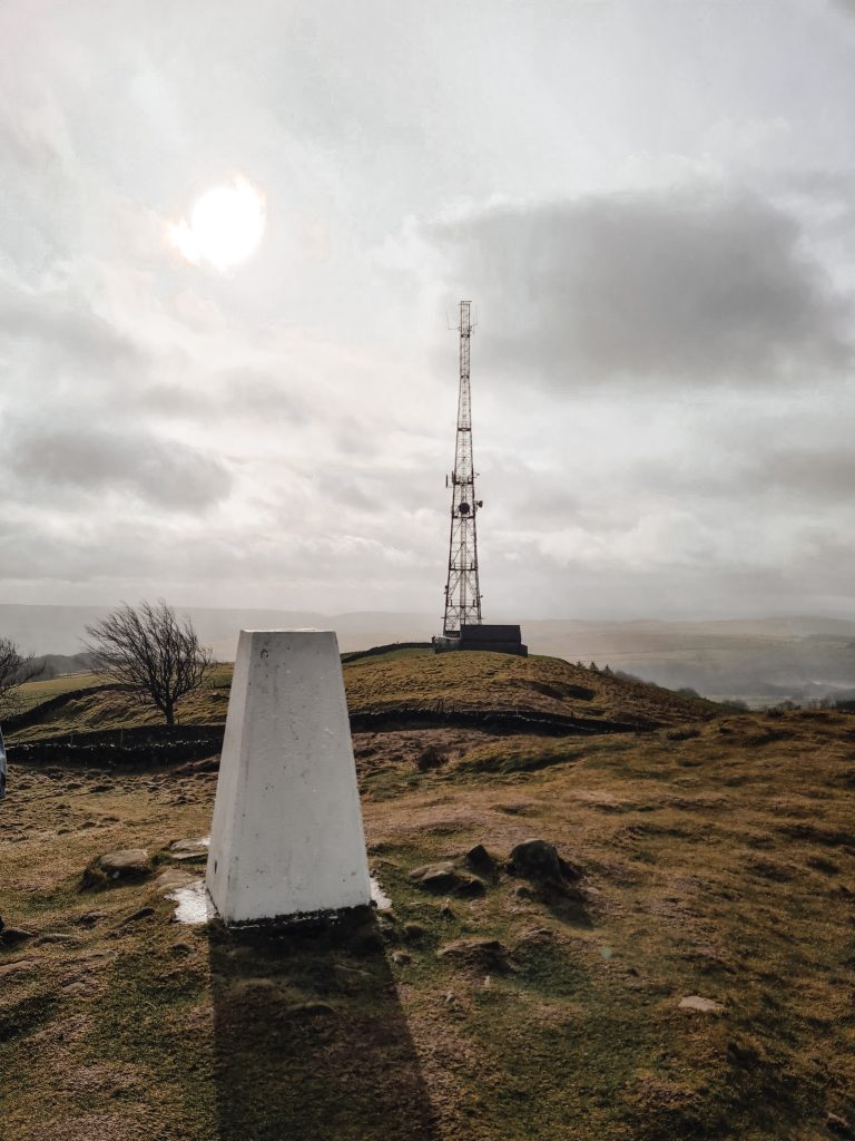
The rather grandly named Sir William Hill trig point is one of the more easily accessible trig points we’ve been to! It’s a short walk along a gravel track from the parking lay-by, and accessed via a stile which leads to a small hill, the summit of which is 429m above sea level. It was however one of the windiest trig points we’ve been to – we could barely stand up!! There are amazing views over the nearby Eyam Moor from here though, and over to Shatton Moor too.

Stile leading to Sir William Hill

Stile leading to Sir William Hill

Sir William Hill trig point

Sir William Hill trig point

Our second trig point of the day was meant to be Durham Edge (Abney Moor). It’s located in a field near the Gliding Club, and I’ve seen online that other people say to call in at the Gliding Club and they’ll show you the best way. We duly called in at the Gliding Club to be met by a rather fed up lady who told us she didn’t want walkers pestering for access to the trig point and it wasn’t on their land. The farmer who owns the land is also fed up with people trespassing in his field to get the trig point. We thought we’d just get as close as we could, which is to within 100m or so using Open Access Land. This is only 6m lower than the actual summit, so #closeenoughisgoodenough for us. It’s a bit frustrating, but as these challenges get more and more popular it must be so irritating for landowners so I totally understand!

Durham Edge trig point

If you look closely on the brow of the hill you can see the Durham Edge trig point!

Our third summit didn’t have a trig point, but is on the Peak District Ethels list. Burton Bole on Shatton Moor is a bleak, featureless moorland plateau some 417m above sea level with views of the surrounding area. When we reached the summit we met another Etheller there – we never normally see any other people so it was nice to chat!


The walk starts in a lay-by near Sir William Hill Road in Bretton, just down the road from The Barrel Inn (Bretton, Hope Valley S32 5QD). I can’t find a road name or a postcode though for the lay-by unfortunately so check the position on the map below. After a quick detour up to the Sir William Hill trig point we retraced our steps and walked along the road to the Gliding Club.


After our chat with the Gliding Club representative, we headed off further along the road until it forked, taking the left hand fork. There is an entrance onto the moors here.


Following the track on the moors for around 0.8 miles, we climbed up the hill to a stile and I followed the wall along to the highest point we could get to on Open Access Land. From the stile you can see the Durham Edge trig point, but you can’t see it from the highest point!


I headed back to the stile where Hols had been having a snack break, and then we set off across the moor, following the track, until we came to a stile leading to the road. Apparently there is the remains of a Robin Hood Cross here, but I couldn’t see anything.


Following the road to the north-east, you’ll come to a gate with lots of byway signs on. Head through this, and then there’s a fence with Shatton Moor behind. We went through the large metal gate (taking care to close it afterwards) and followed the track up to the top of the hill.


After the photos at the summit, we headed back down and meandered through the countryside back to the start of our walk, passing through the pretty village of Abney.

Here’s the walking route for this Sir William Hill trig point walk.


Parking: Lay-by near Sir William Hill Road.

Facilities: None on the walk. We did pass The Barrel Inn but it was closed

Walk Time: 4 hours

Difficulty: ▲▲

Distance: 9 miles (15km)

Trig Points Bagged: Sir William Hill, Abney Moor (ish)

Peak District Peaks Bagged: Sir William Hill, Abney Moor, Shatton Moor

Peak District Ethels Bagged: Sir William Hill, Abney Moor, Shatton Moor

Route Map:

Tap to share with your hiking friends!

  • Facebook
  • Email
  • WhatsApp
« Ecton Hill, Revidge and Wetton Hill Walk | 9 Miles
Best Walks Near Crowden Campsite »

RELATED POSTS

  • Lathkill Dale waterfallLathkill Dale Waterfall Walk | 7 Miles
  • Sheen Hill trig pointSheen Hill Trig Point | 6 Miles
  • A view from Hallin Fell summit with the large stone obeliskWainwrights: 6 Eastern Martindale Fells
  • Wild swimming at Slippery Stones, Derwent Valley - The Wandering WildflowerWild Swimming in the Peak District

Leave a Reply Cancel reply

Your email address will not be published. Required fields are marked *

FIND YOUR NEXT WALK:

ABOUT ME

Y Garn with Kids - Y Garn via the Devil's Kitchen Walk in Ogwen Valley

Hello! I’m Jo! Welcome to The Wandering Wildflower, an outdoors lifestyle blog focusing on family walks in the Peak District, a place we love exploring. I want to share the Peak District hidden gems and show you there’s so much more than the honeypot places. When I’m not dragging my husband and now 11 year old out on Peak District walks or up mountains, I can be found on planning my next moorland walk or plotting a Geocache walk (and seeing where the nearest pub is!). I love the hills but hate the heights, so trig bagging is – er- fun!


I hope this blog will give you some ideas of places to visit in the Peak District and inspire you and your family to head into the great outdoors.  Thanks for stopping by!

CATEGORIES

  • CIRCULAR WALKS (188)
  • HOLMFIRTH WALKS (27)
  • ISLE OF SKYE WALKS (3)
  • LAKE DISTRICT WALKS (24)
  • LANCASHIRE WALKS (2)
  • LONG PEAK DISTRICT WALKS 10 MILES + (42)
  • MEDIUM WALKS 4-9 MILES (136)
  • PEAK DISTRICT SCRAMBLES (16)
  • PEAK DISTRICT WALKS (202)
  • PEAK DISTRICT WALKS WITH KIDS (75)
  • PEAK DISTRICT WALKS WITH PUBS (60)
  • SCOTLAND WALKS (6)
  • SHORT WALKS UNDER 3 MILES (40)
  • SNOWDONIA WALKS (5)
  • UK CAMPING (5)
  • YORKSHIRE WALKS (33)

Peak District Walks

List of Peak District Ethels

Peak District Peak Bagging

Peak District Trig Point Challenge

Peak District Walks with Pubs

Peak District Walks with Kids

Beautiful Walks in Holmfirth

Short Walks in the Peak District

Long Walks in the Peak District

AFFILIATE DISCLOSURE

This blog may contain affiliate links through which, at no additional cost to you, I may earn a small commission. I only recommend products I would use myself and all opinions expressed here are my own. As an Amazon Associate I earn from qualifying purchases. Read full privacy policy here.

ARCHIVES

PEAK DISTRICT WEATHER

Peak District mountain weather on Met Office

Peak District Trig Points

Promo image for a blog post about the Peak District Trig Point Challenge With Map of Peak District Trig Points and Walking Routes by The Wandering Wildflower

Peak District Ethels Challenge

Promo image for a blog post about the Peak District Trig Point Challenge With Map of Peak District Ethels and Walking Routes by The Wandering Wildflower

WALKING ROUTES STRAIGHT TO YOUR INBOX

Want new walks in your inbox? Drop your email below and I'll send you some ideas for walks you can try.

You can unsubscribe anytime. For more details, review our Privacy Policy.

Thank you!

You have successfully joined our subscriber list.

RSS LATEST POSTS

  • Burnbank Fell, Blake Fell and Gavel Fell | 8 Miles
  • Bretton Park Circular Walk | 3 Miles
  • Hathersage Stepping Stones Walk | 7 Miles
  • Ladybower Walk | 6 Miles
  • Derbyshire Peak District Walks

FOLLOW ON PINTEREST

Want new walks in your inbox? Drop your email below and I'll send you some ideas for walks you can try.

You can unsubscribe anytime. For more details, review our Privacy Policy.

Thank you!

You have successfully joined our subscriber list.

jo@thewanderingwildflower.co.uk

The Wandering Wildflower

  • Email
  • Facebook
  • Instagram
  • Pinterest
  • PRIVACY POLICY
  • TERMS & CONDITIONS
  • ABOUT

(c) The Wandering Wildflower. All Rights Reserved.

|| THEME BY ECLAIR DESIGNS