• 3 Mile Walks or Less
  • 4 Mile Walks
  • 5 Mile Walks
  • 6 Mile Walks
  • 7 Mile Walks
  • 8 Mile Walks
  • 9 Mile Walks
  • 10 Mile Walks
  • 11 Mile Walks
  • 12 Mile Walks
  • 14 Mile Walks
  • 15 Mile Walks
  • 20+ Mile Walks

The Wandering Wildflower

Peak District Hikes

  • PEAK DISTRICT WALKS
    • SHORT WALKS UNDER 3 MILES
    • MEDIUM WALKS 4-9 MILES
    • LONG PEAK DISTRICT WALKS 10 MILES +
  • PEAK DISTRICT WALKS WITH PUBS
  • PEAK DISTRICT WALKS WITH KIDS
  • HOLMFIRTH WALKS

High Wheeldon, Pilsbury Hill and Carder Low Walk | 8.5 Miles

April 10, 2022 CIRCULAR WALKS, MEDIUM WALKS 4-9 MILES, PEAK DISTRICT WALKS, PEAK DISTRICT WALKS WITH PUBS

This High Wheeldon walk starts in Earl Sterndale and takes in the neighbouring Peak District Ethels of Pilsbury Hill and Carder Low. At 8.5 miles it’s a nice circular Peak District walk in Dovedale. It’s also a walk with a pub stop, as it passes The Pack Horse Inn in Crowdecote. Winning!

View of High Wheeldon looming in the background

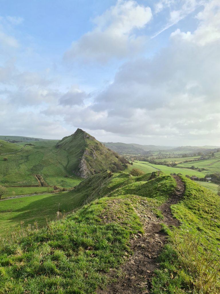
High Wheeldon is a hill near the Staffordshire border in Derbyshire, in the Peak District valley of Upper Dovedale, which stands 422m above sea level. It’s distinctive shape means it can be seen from a good distance away. The High Wheeldon trig point has fabulous views over to Parkhouse Hill, Chrome Hill and the Dragons Back. Slightly below the summit is a cave known as Fox Hole Cave, which is protected by an iron gate. Various items including Bronze Age pottery and a stone axe have been found in the cave, which is a scheduled monument.


Our walk starts from the village of Earl Sterndale outside The Quiet Woman pub. Parking is very limited and gets really busy with people using this as a starting point for a walk to Parkhouse Hill, Chrome Hill and the Dragons Back. We set off in the opposite direction and were soon greeted with the sight of High Wheeldon, looking very much like a pyramid.


Climbing High Wheeldon from this side means you have a very steep ascent. We scrambled up on our hands and feet! If you follow the footpath round the base of the hill there is a more gentle slope and path to get to the top if you don’t fancy a short sharp scramble. The trig point on High Wheeldon has amazing views of the surrounding countryside and you can see for miles on a clear day.

Trig point photos taken and Mini Eggs consumed (our snack for the first day of Spring!) we set off down the hillside and across the fields to our next Ethel of Pilsbury Hill. Other than some limestone outcrops and a tiny cairn, there’s not much on the summit of Pilsbury Hill but it does give fabulous views over Pilsbury Castle down the hillside, next to the river. This is the site of a former mott and bailey castle, of which only some earthworks now remain.

Views over a stile to Pilsbury Hill

Following the footpaths over the fields, we headed to Carder Low, the last of the Ethels on the list for the day.

We passed the summit and headed to the wall, thinking there would be a path onto the Open Access Land beyond but unfortunately there wasn’t. We followed the wall down the hillside and rejoined the footpath, then retraced our steps back to the footpath crossroads. We headed down the valley towards the river, passing by the site of Pilsbury Castle.

Pilsbury Castle site with it’s magnificent rocky outcrop.

We followed the route of the footpath through farmland to The Pack Horse Inn for a well deserved Sunday lunch. I had the roast beef and it was delicious!

The Pack Horse Inn, Crowdecote

I paused my Komoot tracker here, intending to restart it when we left, but I accidentally clicked Finish rather than Resume so the last part of the walk isn’t on the map! It definitely wasn’t down to the glass of wine I had with lunch! It’s easy to find though – follow the road up the hill for a short distance and take the road on the left, which will take you past Crowdecote campsite. This lane will take you back past High Wheeldon and back to where you parked. It’s about 1.5 miles in total and you can see this on the second map below.


This was a lovely walk to do in the beautiful Dovedale valley, and it was great to tick 3 more Ethels off our to do list! You can see more Peak District Ethels walks on the blog.


High Wheeldon Trig Point Walk:

FULL ROUTE Walk Map (opens in OS Maps): High Wheeldon, Pilsbury Hill and Carder Low

Parking: On street parking in Earl Sterndale, Buxton SK17 0BX – please be considerate to local residents (who must despair at the parking situation on a sunny weekend day!)

Facilities: The walk passes The Pack Horse Inn in Crowdecote but there are no public toilets.

Walk Time: 3 hours

Difficulty: ▲▲ (High Wheeldon is very steep this way but there is a more gradual climb round the other side, and there are a couple of other steep climbs)

Distance: 8.5 miles (13.7km) in total

Trig Points Bagged: High Wheeldon

Peak District Peaks Bagged: High Wheeldon, Pilsbury Hill, Carder Low

Peak District Ethels Bagged: High Wheeldon, Pilsbury Hill, Carder Low


Some other nearby walks include Chrome Hill, Parkhouse Hill, High Edge and Hollins Hill 4 Peaks and Thorpe Cloud, Dovedale Stepping Stones, Bunster Hill and Ilam.

Tap to share with your hiking friends!

  • Facebook
  • Email
  • WhatsApp
« 10 Easy Peak District Walks With Kids (Under 10km)
Yorkshire 3 Peaks Route & GPX | 24 Miles »

RELATED POSTS

  • Three Shires HeadHow to Find Three Shires Head
  • Lathkill Dale waterfallLathkill Dale Waterfall Walk | 7 Miles
  • Sheen Hill trig pointSheen Hill Trig Point | 6 Miles
  • View down a field to an old engine houseEcton Hill, Revidge and Wetton Hill Walk | 9 Miles

Leave a Reply Cancel reply

Your email address will not be published. Required fields are marked *

FIND YOUR NEXT WALK:

ABOUT ME

Y Garn with Kids - Y Garn via the Devil's Kitchen Walk in Ogwen Valley

Hello! I’m Jo! Welcome to The Wandering Wildflower, an outdoors lifestyle blog focusing on family walks in the Peak District, a place we love exploring. I want to share the Peak District hidden gems and show you there’s so much more than the honeypot places. When I’m not dragging my husband and now 11 year old out on Peak District walks or up mountains, I can be found on planning my next moorland walk or plotting a Geocache walk (and seeing where the nearest pub is!). I love the hills but hate the heights, so trig bagging is – er- fun!


I hope this blog will give you some ideas of places to visit in the Peak District and inspire you and your family to head into the great outdoors.  Thanks for stopping by!

CATEGORIES

  • CIRCULAR WALKS (189)
  • HOLMFIRTH WALKS (27)
  • ISLE OF SKYE WALKS (3)
  • LAKE DISTRICT WALKS (26)
  • LANCASHIRE WALKS (2)
  • LONG PEAK DISTRICT WALKS 10 MILES + (42)
  • MEDIUM WALKS 4-9 MILES (137)
  • PEAK DISTRICT SCRAMBLES (16)
  • PEAK DISTRICT WALKS (206)
  • PEAK DISTRICT WALKS WITH KIDS (76)
  • PEAK DISTRICT WALKS WITH PUBS (60)
  • SCOTLAND WALKS (6)
  • SHORT WALKS UNDER 3 MILES (40)
  • SNOWDONIA WALKS (5)
  • UK CAMPING (5)
  • YORKSHIRE WALKS (33)

Peak District Walks

List of Peak District Ethels

Peak District Peak Bagging

Peak District Trig Point Challenge

Peak District Walks with Pubs

Peak District Walks with Kids

Beautiful Walks in Holmfirth

Short Walks in the Peak District

Long Walks in the Peak District

AFFILIATE DISCLOSURE

This blog may contain affiliate links through which, at no additional cost to you, I may earn a small commission. I only recommend products I would use myself and all opinions expressed here are my own. As an Amazon Associate I earn from qualifying purchases. Read full privacy policy here.

ARCHIVES

PEAK DISTRICT WEATHER

Peak District mountain weather on Met Office

Peak District Trig Points

Promo image for a blog post about the Peak District Trig Point Challenge With Map of Peak District Trig Points and Walking Routes by The Wandering Wildflower

Peak District Ethels Challenge

Promo image for a blog post about the Peak District Trig Point Challenge With Map of Peak District Ethels and Walking Routes by The Wandering Wildflower

WALKING ROUTES STRAIGHT TO YOUR INBOX

Want new walks in your inbox? Drop your email below and I'll send you some ideas for walks you can try.

You can unsubscribe anytime. For more details, review our Privacy Policy.

Thank you!

You have successfully joined our subscriber list.

RSS LATEST POSTS

  • How to Find Three Shires Head
  • Peak District Pub Walks
  • Burnbank Fell, Blake Fell and Gavel Fell | 8 Miles
  • Bretton Park Circular Walk | 3 Miles
  • Grasmere Weekend Break

FOLLOW ON PINTEREST

Want new walks in your inbox? Drop your email below and I'll send you some ideas for walks you can try.

You can unsubscribe anytime. For more details, review our Privacy Policy.

Thank you!

You have successfully joined our subscriber list.

jo@thewanderingwildflower.co.uk

The Wandering Wildflower

  • Email
  • Facebook
  • Instagram
  • Pinterest
  • PRIVACY POLICY
  • TERMS & CONDITIONS
  • ABOUT

(c) The Wandering Wildflower. All Rights Reserved.

|| THEME BY ECLAIR DESIGNS