• 3 Mile Walks or Less
  • 4 Mile Walks
  • 5 Mile Walks
  • 6 Mile Walks
  • 7 Mile Walks
  • 8 Mile Walks
  • 9 Mile Walks
  • 10 Mile Walks
  • 11 Mile Walks
  • 12 Mile Walks
  • 14 Mile Walks
  • 15 Mile Walks
  • 20+ Mile Walks

The Wandering Wildflower

Peak District Hikes

  • PEAK DISTRICT WALKS
    • SHORT WALKS UNDER 3 MILES
    • MEDIUM WALKS 4-9 MILES
    • LONG PEAK DISTRICT WALKS 10 MILES +
  • PEAK DISTRICT WALKS WITH PUBS
  • PEAK DISTRICT WALKS WITH KIDS
  • HOLMFIRTH WALKS

South Nab Trig Point and Windleden Reservoirs | 4 Miles

October 9, 2021 CIRCULAR WALKS, HOLMFIRTH WALKS, MEDIUM WALKS 4-9 MILES, PEAK DISTRICT WALKS, PEAK DISTRICT WALKS WITH PUBS, YORKSHIRE WALKS

This is a circular hike taking in the trig point at South Nab and Windleden Reservoirs, both Upper Windleden and Lower Windleden. It’s a great walk for kids as it’s not challenging but does use Open Access moorland so be sure to check the rules on dogs before taking your furry friends along as there are ground nesting birds and livestock on the moors. At 4 miles, this is a lovely family friendly moorland walk in the Peak District.


South Nab Trig Point - The Wandering Wildflower

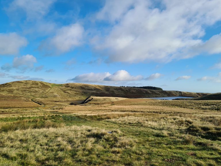
Upper and Lower Windleden Reservoirs are much less busy than their neighbour Winscar Reservoir, presumably because there are no paths around so they’re much harder going. Still, they’re definitely worth a visit and my thanks go to Geocache user MeltedIceberg for once again introducing us this beautiful location.


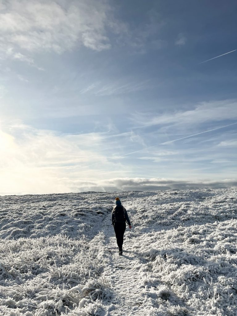
The trig point at South Nab is 460.9m above sea level and is one of the easier ones to access – see sneaky tip later on!


We started from the Trans Pennine Trail car park at Dunford Bridge and set off up the hill. The first part of the walk is uphill but on roads, so the going is pretty easy.

Peak District Gateway at Dunford Bridge - The Wandering Wildflower


This blog may contain affiliate links through which, at no additional cost to you, I may earn a small commission. I only recommend products I would use myself and all opinions expressed here are my own. Read full privacy policy here.


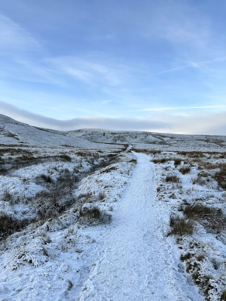
You’ll come to a public bridleway sign on the left hand side of the road, which puts you onto the moorland. Although this is Open Access land, there is a visible path you can follow. It was a bit muddy when we went so I’d recommend proper hiking boots or wellies for little ones.


Upper Windleden Reservoir - The Wandering Wildflower

Upper Windleden Reservoir

Bridge over the Clough

The path takes you down across Brown’s Clough and back up the other side of the valley. Hols found this a bit tough but with plenty of rest stops (and Haribo) she managed it.


Gatepost at the top of the hill, giving access to moorland


South Nab Trig Point on the horizon


South Nab Trig Point with Views - The Wandering Wildflower

South Nab Trig Point with the three reservoirs in the background


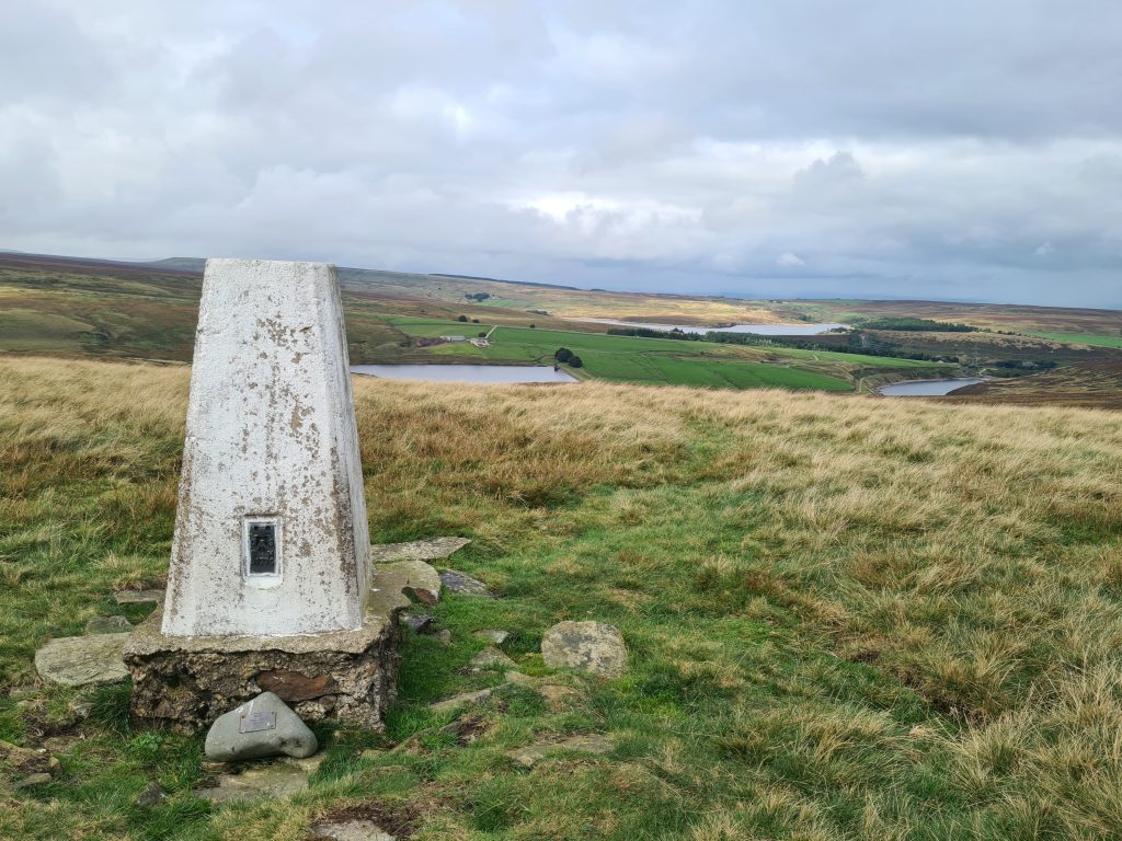
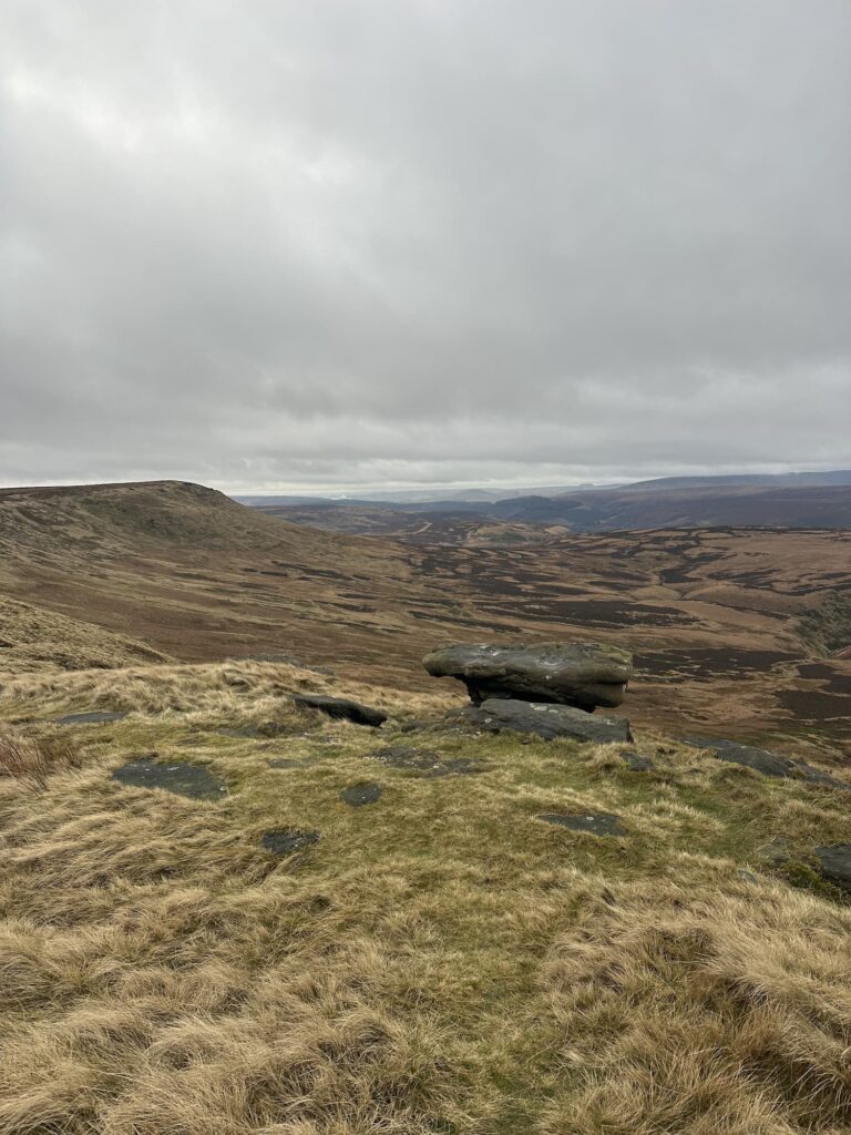
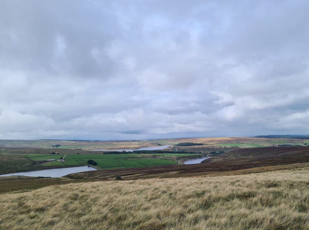
There’s a bit of a trek across moorland until you get to the trig point itself. From here there are amazing views over 3 reservoirs (I think Winscar, Upper Windleden and Lower Windleden) and scenic views over the moorland.


South Nab Trig Point with a moody autumnal sky


The last of the summer heather


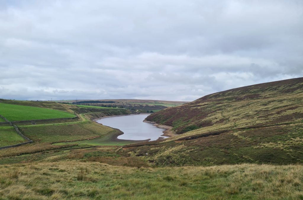
From the trig point we headed across the moors towards Upper Windleden Reservoir, keeping to the right hand side of Glead Nest Clough. There is a rough path of sorts to follow between the heather.


Lower Windleden Reservoir is next to pass, and this is where we came a cropper. Mr R fell in a manmade trench hidden in the heather near to the reservoir dam. He was OK, but fell in up to his waist and was bruised. Be sure to take care here, especially if the heather and bracken are thick. We also ended up walking across the reservoir embankment but there is no right of way across there and we were technically trespassing. Sorry Yorkshire Water!


Lower Windleden Reservoir

Lower Windleden Reservoir

We should have followed Clough Beck down to the road or footpath. You can see on the map below (when enlarged) the tan/mushroom colour, which is the Open Access land, and the lighter beige colour which is Yorkshire Water owned land. Don’t go on there! I can’t change the blooming map though! Rather than turning left back to A after the reservoir, we should have gone straight on.


As a side note, if you did just want to bag this South Nab trig point you could park on the main A628 road in one of the lay-bys there and walk a short distance to the trig. I always like to have a little wander if I can though!


This was the first of our recent Peak District walks that has felt autumnal. The heather was all dead (although I bet it looked stunning in August so I’ll be revisiting then if I can) and the grass was long and blonde.


As there was no pub at Dunford Bridge we drove to the Boshaw Trout at Hade Edge and had a lovely few too many wines (me) and a pub tea.


I hope you try this South Nab and Windleden Reservoirs walk, not just for the trig point at South Nab but also for the moorland views. You can see our Trig Bagging list and Peak Bagging list for ideas for more walks in the Peak District.

Tap to share with your hiking friends!

  • Facebook
  • Email
  • WhatsApp
« Black Chew Head via Laddow Rocks Walk | 6 Miles
Pule Hill Circular Walk | 6 Miles »

RELATED POSTS

  • Hathersage Stepping StonesHathersage Stepping Stones Walk | 7 Miles
  • Ladybower ReservoirLadybower Walk | 6 Miles
  • Anvil Stone, GrindsbrookGrindsbrook Clough Scramble to Grindslow Knoll | 7 Miles
  • Boots Folly, a small castle like structureDerwent Edge, Derwent Moors and Boots Folly | 8.5 Miles

Leave a Reply Cancel reply

Your email address will not be published. Required fields are marked *

FIND YOUR NEXT WALK:

ABOUT ME

Y Garn with Kids - Y Garn via the Devil's Kitchen Walk in Ogwen Valley

Hello! I’m Jo! Welcome to The Wandering Wildflower, an outdoors lifestyle blog focusing on family walks in the Peak District, a place we love exploring. I want to share the Peak District hidden gems and show you there’s so much more than the honeypot places. When I’m not dragging my husband and now 11 year old out on Peak District walks or up mountains, I can be found on planning my next moorland walk or plotting a Geocache walk (and seeing where the nearest pub is!). I love the hills but hate the heights, so trig bagging is – er- fun!


I hope this blog will give you some ideas of places to visit in the Peak District and inspire you and your family to head into the great outdoors.  Thanks for stopping by!

CATEGORIES

  • CIRCULAR WALKS (188)
  • HOLMFIRTH WALKS (27)
  • ISLE OF SKYE WALKS (3)
  • LAKE DISTRICT WALKS (24)
  • LANCASHIRE WALKS (2)
  • LONG PEAK DISTRICT WALKS 10 MILES + (42)
  • MEDIUM WALKS 4-9 MILES (136)
  • PEAK DISTRICT SCRAMBLES (16)
  • PEAK DISTRICT WALKS (202)
  • PEAK DISTRICT WALKS WITH KIDS (75)
  • PEAK DISTRICT WALKS WITH PUBS (60)
  • SCOTLAND WALKS (6)
  • SHORT WALKS UNDER 3 MILES (40)
  • SNOWDONIA WALKS (5)
  • UK CAMPING (5)
  • YORKSHIRE WALKS (33)

Peak District Walks

List of Peak District Ethels

Peak District Peak Bagging

Peak District Trig Point Challenge

Peak District Walks with Pubs

Peak District Walks with Kids

Beautiful Walks in Holmfirth

Short Walks in the Peak District

Long Walks in the Peak District

AFFILIATE DISCLOSURE

This blog may contain affiliate links through which, at no additional cost to you, I may earn a small commission. I only recommend products I would use myself and all opinions expressed here are my own. As an Amazon Associate I earn from qualifying purchases. Read full privacy policy here.

ARCHIVES

PEAK DISTRICT WEATHER

Peak District mountain weather on Met Office

Peak District Trig Points

Promo image for a blog post about the Peak District Trig Point Challenge With Map of Peak District Trig Points and Walking Routes by The Wandering Wildflower

Peak District Ethels Challenge

Promo image for a blog post about the Peak District Trig Point Challenge With Map of Peak District Ethels and Walking Routes by The Wandering Wildflower

WALKING ROUTES STRAIGHT TO YOUR INBOX

Want new walks in your inbox? Drop your email below and I'll send you some ideas for walks you can try.

You can unsubscribe anytime. For more details, review our Privacy Policy.

Thank you!

You have successfully joined our subscriber list.

RSS LATEST POSTS

  • Burnbank Fell, Blake Fell and Gavel Fell | 8 Miles
  • Bretton Park Circular Walk | 3 Miles
  • Hathersage Stepping Stones Walk | 7 Miles
  • Ladybower Walk | 6 Miles
  • Derbyshire Peak District Walks

FOLLOW ON PINTEREST

Want new walks in your inbox? Drop your email below and I'll send you some ideas for walks you can try.

You can unsubscribe anytime. For more details, review our Privacy Policy.

Thank you!

You have successfully joined our subscriber list.

jo@thewanderingwildflower.co.uk

The Wandering Wildflower

  • Email
  • Facebook
  • Instagram
  • Pinterest
  • PRIVACY POLICY
  • TERMS & CONDITIONS
  • ABOUT

(c) The Wandering Wildflower. All Rights Reserved.

|| THEME BY ECLAIR DESIGNS