• 3 Mile Walks or Less
  • 4 Mile Walks
  • 5 Mile Walks
  • 6 Mile Walks
  • 7 Mile Walks
  • 8 Mile Walks
  • 9 Mile Walks
  • 10 Mile Walks
  • 11 Mile Walks
  • 12 Mile Walks
  • 14 Mile Walks
  • 15 Mile Walks
  • 20+ Mile Walks

The Wandering Wildflower

Peak District Hikes

  • PEAK DISTRICT WALKS
    • SHORT WALKS UNDER 3 MILES
    • MEDIUM WALKS 4-9 MILES
    • LONG PEAK DISTRICT WALKS 10 MILES +
  • PEAK DISTRICT WALKS WITH PUBS
  • PEAK DISTRICT WALKS WITH KIDS
  • HOLMFIRTH WALKS

Axe Edge Trig Point and Three Shires Head Walk | 10 Miles

January 20, 2022 CIRCULAR WALKS, LONG PEAK DISTRICT WALKS 10 MILES +, MEDIUM WALKS 4-9 MILES, PEAK DISTRICT WALKS, PEAK DISTRICT WALKS WITH PUBS

Looking for a walking route for the Axe Edge trig point? This walk takes in Axe Edge trig point, Oliver Hill, Cheeks Hill and heads back via Three Shires Head. With 3 Peak District Ethels, a trig point and the beautiful surroundings of Three Shires Head, this circular Peak District walk is 15km.

Ace Edge trig point on Axe Edge Moor

We started this walk with the intention of getting the three Peak District Ethels of Oliver Hill, Cheeks Hill and Axe Edge before heading back over Axe Edge Moor back to the car. The walk should have been 10km but when we came to cross Axe Edge Moor, it was so boggy and wet, and the visibility was really poor so we decided to detour back via Three Shires Head instead. It added another 5km onto the walk but it was definitely worth it.

Our walk starts in the village of Flash outside The New Inn with the claim to being the highest village inn in Britain. Unfortunately for us it was closed, so no pub lunch for us today! Parking in the village is very limited so if you do park here please be considerate to residents.


The New Inn, Flash

The New Inn, Flash


We headed off up the public footpath to Oliver Hill at 513m above sea level. This unassuming peak is surrounded by farmland and has a tiny cairn to mark the top. The footpath runs to the west of the summit and then Open Access Land is used to access the cairn.

Oliver Hill summit cairn

Oliver Hill summit cairn


From Oliver Hill we took the Open Access Land back to the footpath and headed towards Cheeks Hill. This part of the walk is on tarmac driveways and gravel tracks, which makes the going quite easy. Cheeks Hill is a featureless summit at 520m above sea level but is actually the County Top of Staffordshire. There is a small sheep fold nearby, but other than that it’s just open moorland.


Cheeks Hill summit. Blank, featureless moorland!

Cheeks Hill summit. Blank, featureless moorland!


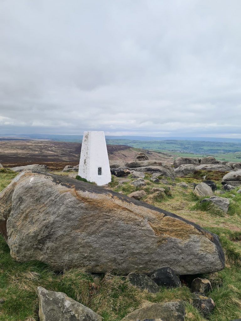
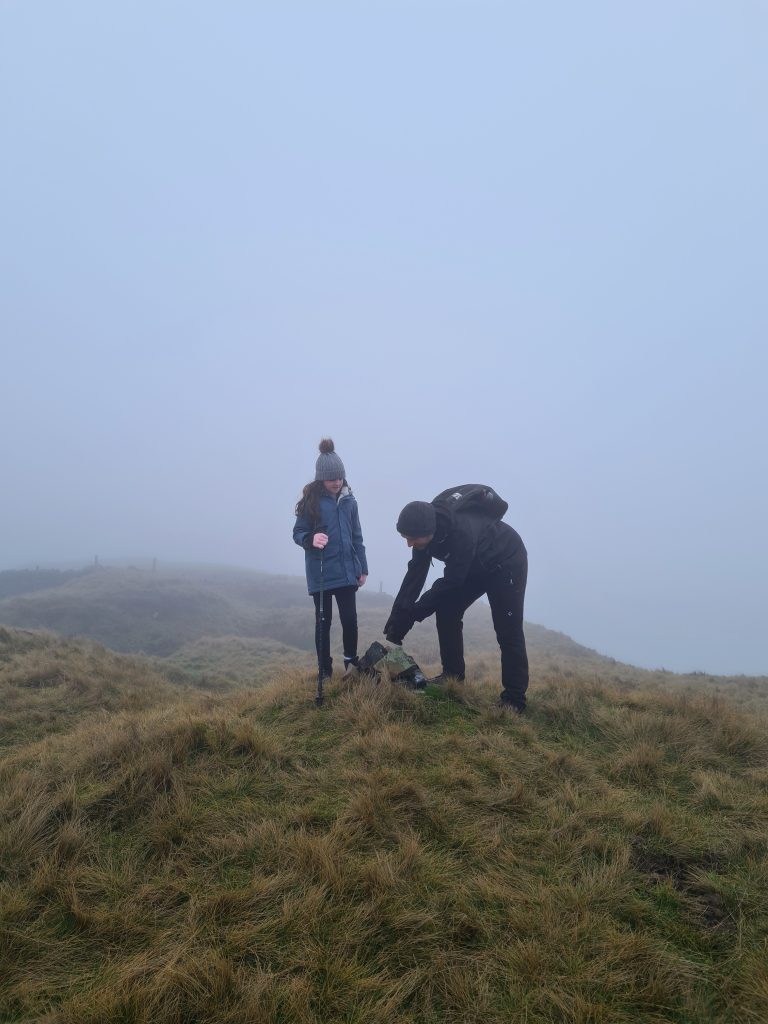
Our route then heads out onto the road and through the gate onto Axe Edge Moor. Axe Edge trig point is about 0.5km from the road over bleak, boggy moorland. Hols tripped over a grassy tussock and fell into the peaty puddles, soaking her gloves and legs. Luckily we had spare clothes and gloves for her as it was freezing cold!


Peaty, wet moorland on Axe Edge Moor in the Peak District

Peaty, wet moorland on Axe Edge Moor

A bleak looking Axe Edge Moor trig point

A bleak looking Axe Edge Moor trig point


Photos of Axe Edge trig point duly taken, we set off back to the road to try and cross Axe Edge Moor. Unfortunately the visibility was really poor and the moors were really wet and boggy, so rather than get lost on the moors or end up soaking wet in a peat bog we decided to detour to Three Shires Head. You can see on the route map where we tried to cross the moor and aborted our mission!


Road to Three Shires Head

Road to Three Shires Head

Road to Three Shires Head

Road to Three Shires Head

Small bridge over the River Dane

Small bridge over the River Dane

Lone tree in the mist near the River Dane

Lone tree in the mist near the River Dane

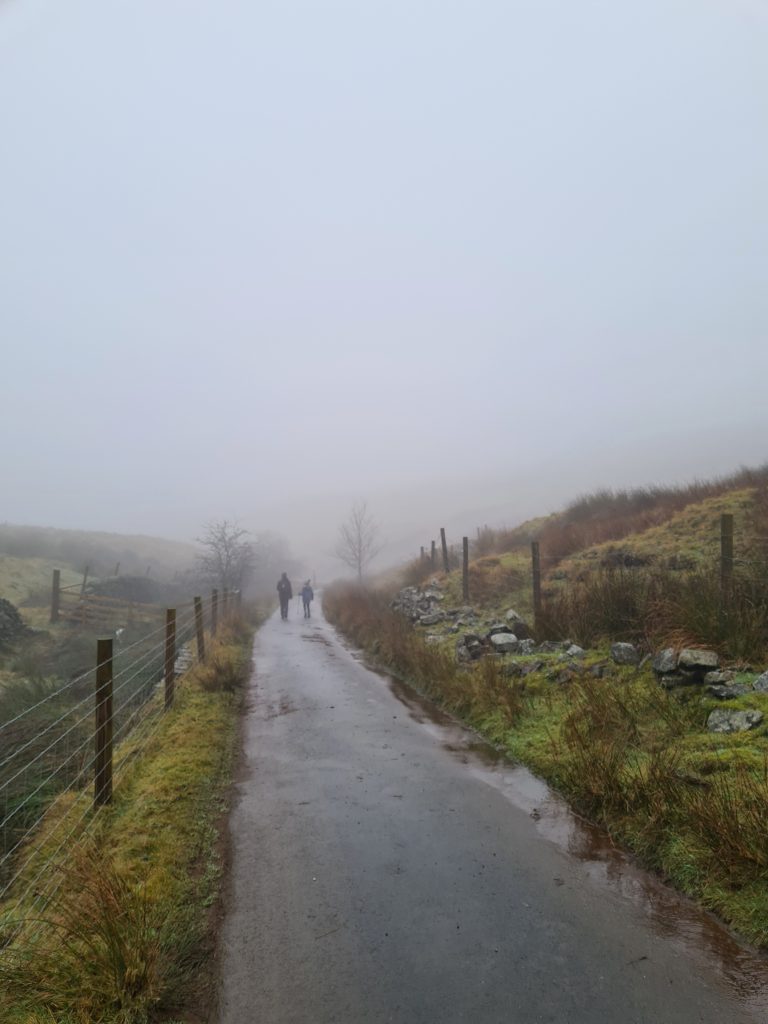
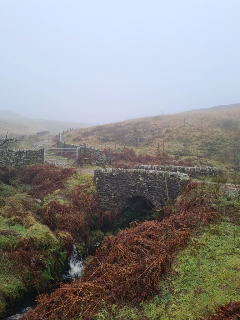
We went back via Cheeks Hill and followed Dry Stones Edge Road. There is a footpath that leads off alongside the river which flows through a really picturesque valley. Follow this path which will take you down to Three Shires Head, so called because it’s where three counties border each other. This former packhorse route is a beautiful place to explore and is a favourite place among wild swimmers. Despite the weather and the cold temperatures when we went it was still a really popular place with walkers and photographers – I had to wait an age for there to be no-one in this picture and still had to blur some people out of it!


Three Shires Head, Peak District - Best Peak District Walks

Three Shires Head


We didn’t hang around too long here as it was quite busy, so we headed off back along the packhorse trails alongside the River Dane. The route takes you through farmland and then back up the hill to the village of Flash. It is a bit of a slog up the hill, especially as this is the last climb up after walking all that way!


You’ll end up back in Flash at The New Inn, which may or may not be open. It would be best to ring beforehand if you wanted to make this a Peak District walk with a pub stop.


I have a list of Peak District Ethels with walks that we have done to bag them, if you fancy taking part in the Ethel Bagging challenge too.


Here’s the route for this Peak District walk:

Route Map: Please note this has the bits where we tried to go over Axe Edge Moor and couldn’t, so if using Komoot as a sat nav style guide ignore those bits. After the trig point visit, get back onto the road and head down towards Three Shires Head.

Parking: Limited parking outside the New Inn, Flash SK17 0SW

Facilities: None if the pub is shut

Walk Time: 3-4 hours

Difficulty: ▲▲▲

Terrain: Road and very boggy moorland near Axe Edge trig point

Distance: 9.5 miles (15km) approximately

Trig Points Bagged: Axe Edge Moor

Peak District Peaks Bagged: Axe Edge Moor, Cheeks Hill, Oliver Hill

Peak District Ethels Bagged: Axe Edge Moor, Cheeks Hill, Oliver Hill


For a shorter walk to Three Shires Head why not try: How to Find Three Shires Head


You can check out our Peak District trig point walks and Peak District peak bagging walks too.

Tap to share with your hiking friends!

  • Facebook
  • Email
  • WhatsApp
« How to Find The Trinnacle at Dove Stone | 5 Miles
Underbank Reservoir Walk | 3 Miles »

RELATED POSTS

  • Three Shires HeadHow to Find Three Shires Head
  • Lathkill Dale waterfallLathkill Dale Waterfall Walk | 7 Miles
  • Sheen Hill trig pointSheen Hill Trig Point | 6 Miles
  • Sunrise over The Great Ridge from Mam Tor - Peak District Sunrises - The Wandering WildflowerMam Tor Short Walk | 1 Mile

Leave a Reply Cancel reply

Your email address will not be published. Required fields are marked *

FIND YOUR NEXT WALK:

ABOUT ME

Y Garn with Kids - Y Garn via the Devil's Kitchen Walk in Ogwen Valley

Hello! I’m Jo! Welcome to The Wandering Wildflower, an outdoors lifestyle blog focusing on family walks in the Peak District, a place we love exploring. I want to share the Peak District hidden gems and show you there’s so much more than the honeypot places. When I’m not dragging my husband and now 11 year old out on Peak District walks or up mountains, I can be found on planning my next moorland walk or plotting a Geocache walk (and seeing where the nearest pub is!). I love the hills but hate the heights, so trig bagging is – er- fun!


I hope this blog will give you some ideas of places to visit in the Peak District and inspire you and your family to head into the great outdoors.  Thanks for stopping by!

CATEGORIES

  • CIRCULAR WALKS (189)
  • HOLMFIRTH WALKS (27)
  • ISLE OF SKYE WALKS (3)
  • LAKE DISTRICT WALKS (24)
  • LANCASHIRE WALKS (2)
  • LONG PEAK DISTRICT WALKS 10 MILES + (42)
  • MEDIUM WALKS 4-9 MILES (137)
  • PEAK DISTRICT SCRAMBLES (16)
  • PEAK DISTRICT WALKS (205)
  • PEAK DISTRICT WALKS WITH KIDS (76)
  • PEAK DISTRICT WALKS WITH PUBS (60)
  • SCOTLAND WALKS (6)
  • SHORT WALKS UNDER 3 MILES (40)
  • SNOWDONIA WALKS (5)
  • UK CAMPING (5)
  • YORKSHIRE WALKS (33)

Peak District Walks

List of Peak District Ethels

Peak District Peak Bagging

Peak District Trig Point Challenge

Peak District Walks with Pubs

Peak District Walks with Kids

Beautiful Walks in Holmfirth

Short Walks in the Peak District

Long Walks in the Peak District

AFFILIATE DISCLOSURE

This blog may contain affiliate links through which, at no additional cost to you, I may earn a small commission. I only recommend products I would use myself and all opinions expressed here are my own. As an Amazon Associate I earn from qualifying purchases. Read full privacy policy here.

ARCHIVES

PEAK DISTRICT WEATHER

Peak District mountain weather on Met Office

Peak District Trig Points

Promo image for a blog post about the Peak District Trig Point Challenge With Map of Peak District Trig Points and Walking Routes by The Wandering Wildflower

Peak District Ethels Challenge

Promo image for a blog post about the Peak District Trig Point Challenge With Map of Peak District Ethels and Walking Routes by The Wandering Wildflower

WALKING ROUTES STRAIGHT TO YOUR INBOX

Want new walks in your inbox? Drop your email below and I'll send you some ideas for walks you can try.

You can unsubscribe anytime. For more details, review our Privacy Policy.

Thank you!

You have successfully joined our subscriber list.

RSS LATEST POSTS

  • How to Find Three Shires Head
  • Burnbank Fell, Blake Fell and Gavel Fell | 8 Miles
  • Bretton Park Circular Walk | 3 Miles
  • Hathersage Stepping Stones Walk | 7 Miles
  • Peak District Caves

FOLLOW ON PINTEREST

Want new walks in your inbox? Drop your email below and I'll send you some ideas for walks you can try.

You can unsubscribe anytime. For more details, review our Privacy Policy.

Thank you!

You have successfully joined our subscriber list.

jo@thewanderingwildflower.co.uk

The Wandering Wildflower

  • Email
  • Facebook
  • Instagram
  • Pinterest
  • PRIVACY POLICY
  • TERMS & CONDITIONS
  • ABOUT

(c) The Wandering Wildflower. All Rights Reserved.

|| THEME BY ECLAIR DESIGNS