• 3 Mile Walks or Less
  • 4 Mile Walks
  • 5 Mile Walks
  • 6 Mile Walks
  • 7 Mile Walks
  • 8 Mile Walks
  • 9 Mile Walks
  • 10 Mile Walks
  • 11 Mile Walks
  • 12 Mile Walks
  • 14 Mile Walks
  • 15 Mile Walks
  • 20+ Mile Walks

The Wandering Wildflower

Peak District Hikes

  • PEAK DISTRICT WALKS
    • SHORT WALKS UNDER 3 MILES
    • MEDIUM WALKS 4-9 MILES
    • LONG PEAK DISTRICT WALKS 10 MILES +
  • PEAK DISTRICT WALKS WITH PUBS
  • PEAK DISTRICT WALKS WITH KIDS
  • HOLMFIRTH WALKS

Old Glossop to Bleaklow Head and Cock Hill Circular | 8 Miles

July 10, 2023 CIRCULAR WALKS, MEDIUM WALKS 4-9 MILES, PEAK DISTRICT WALKS, PEAK DISTRICT WALKS WITH PUBS

This Peak District walk explores one of the quieter parts of the National Park, starting from Old Glossop and heading up onto Bleaklow Head and round to Cock Hill via Widboar Grain and Torside Castle. This 8 mile walk heads out over wild, rugged terrain, and good navigation and sturdy footwear are definitely necessary.

Bleaklow Head summit marker, a 6 foot tall pole in a pile of rocks

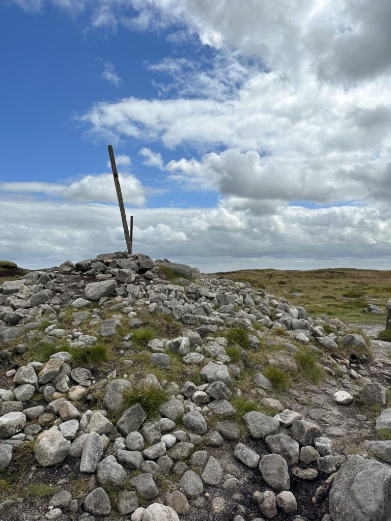
Bleaklow Head is one of the most recognisable summits in the Peak District, being on the Pennine Way and marked by a stake in a cairn. It’s also one of the most inhospitable – the weather can change quickly up here and it’s not unusual to experience four seasons in one day! In his Pennine Way Companion, Alfred Wainwright  describes Bleaklow as

an inhospitable wilderness of peatbogs over which progress on foot is very arduous. The Pennine Way in fact lets walkers off lightly, touching only the fringe of this black desert. Nobody loves Bleaklow. All who get on it are glad to get off.

I know, I’m really selling it to you! Bleaklow is also one of the most wildly beautiful places in the Peak District where you can experience peace and solitude and see an abundance of wildlife including mountain hares and various birds, frogs, lizards and more. It makes for a great days walking and personally, I love Bleaklow!


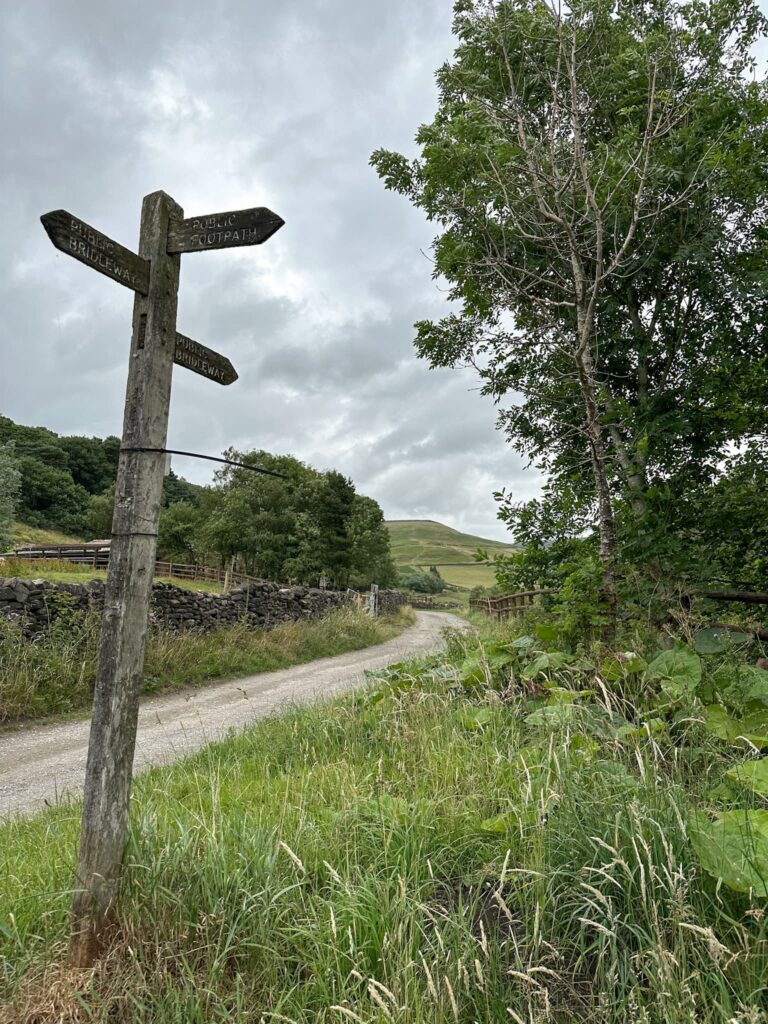
Our route starts from Old Glossop where we parked on a side street (as the car park was full), and we set off down the pretty Wesley Street and onto Shepley Street with its quaint old cottages. Carrying on Shepley Street past the large industrial units, we picked up the footpath just after Shittern Clough and the clay pigeon shooting club. On the Sunday morning we did this walk, the guns were firing and it meant we had to abandon our plans of exploring Shittern Clough. Instead we followed the footpath up the hill, past the remains of the shooting range.

A wooden signpost with 3 markers

A Victorian shooting range target on the moors

During the Crimean war it was decided that there was a need for volunteer riflemen, a kind of early Dad’s Army, and various shooting ranges were put up for them to practice (there’s one in Ramsden Clough and one in the Crowden Valley, along with this one). This one still has some of the targets in situ.


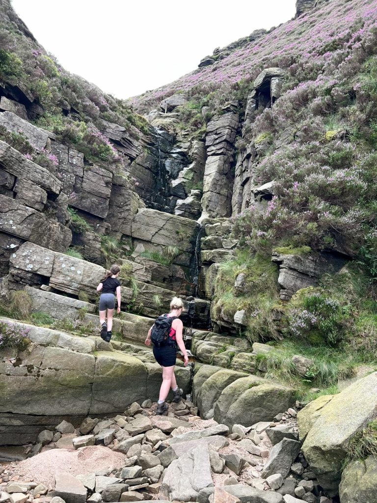
After having a look around the shooting targets we carried on up Lightside up the hill, enjoying the views down over Dowstone Clough (which is a great scramble). We had lunch by the Dog Rock and then followed the path up onto Bleaklow itself. The path is faint in places.

A moorland view with some purple heather in the foreground

A view up the rocky ravine of Dowstone Clough

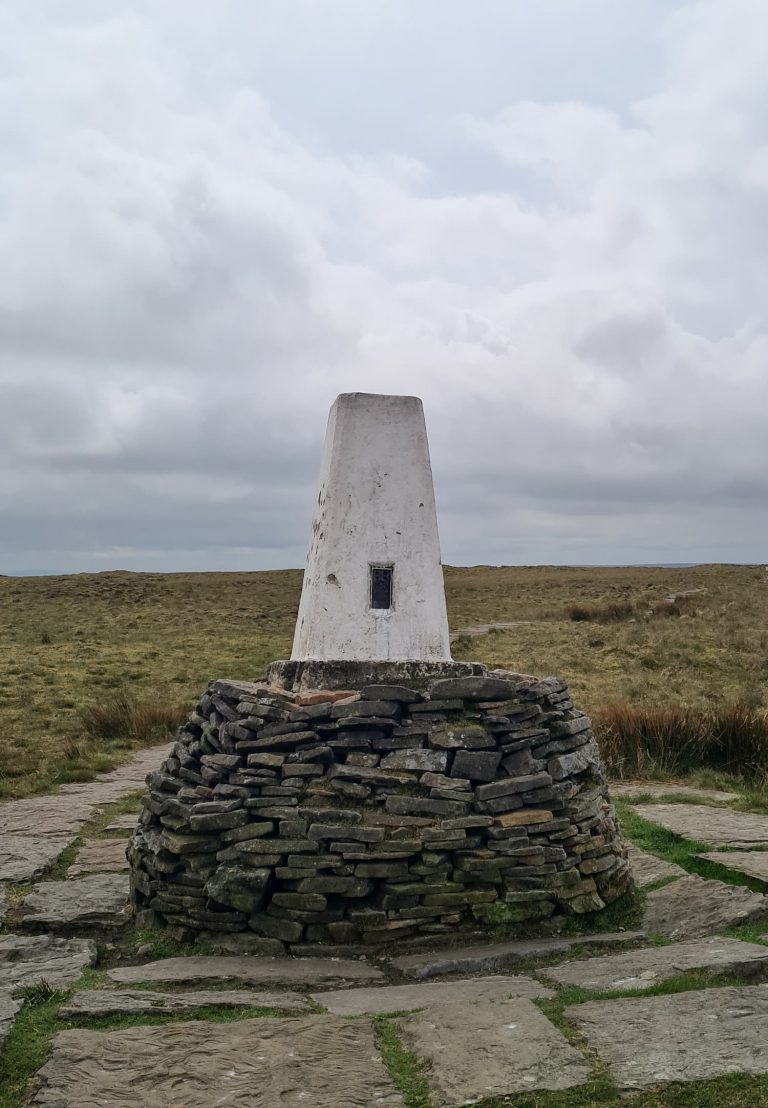
At the Hern Stones we turned north to head to the Wain Stones aka the Kissing Stones or the Kiss, and then made the short trip to Bleaklow Head (633m). The summit is marked by a stake in a pile of stones and is a very welcome sight in bad weather!


Bleaklow Head summit marker, a 6 foot tall pole in a pile of rocks

We then set off along the Pennine Way to the north-west, following Wildboar Grain as it flows west and meets Torside Clough. At the junction we picked up the path to the west heading past the strange Torside Castle, which was once thought to be the site of a castle or fort but now is thought to be a natural mound. Whatever it is, it’s a bit strange!

A collection of gritstone rocks known as the Wain Stones on Bleakllow

The route heads west following the course of Wildboar Grain, which can be very wet and peaty, and heads over to the Cock Hill trig point after passing this old shooting cabin. There’s not much left of it now!

A dilapidated stone shooting cabin with no roof and only partial walls

Cock Hill trig point, a white concrete pillar

A path leading down off the moors with lots of purple heather to the side of it.

Some spoil heaps from a former quarry, now covered in grass, with lots of purple heather in the foreground

From here we walked down the old quarry track to where it joins Charles Lane, and then we walked back to the car. We finished the day with a drink in the Wheatsheaf Inn.


Walk Details:

Mossy Lea to Bleaklow and Cock Hill Walk Map:


Walk Map (Opens in OS Maps): Old Glossop to Bleaklow Head and Cock Hill

Parking: On street in Old Glossop – be mindful of residents!

Facilities: There are no facilities

Walk Time: 4-5 hours

Difficulty: ▲▲▲

Distance: 8.3 miles (13.35km)

Trig Points Bagged: Cock Hill

Peak District Peaks Bagged: Bleaklow Head, Cock Hill

Peak District Ethels Bagged: Bleaklow Head


Some more walks on Bleaklow you may like:

Shining Clough Scramble to Bleaklow

Middle Black Clough Waterfall and Bleaklow Stones

Alport Moor and Bleaklow Walking Route

Bleaklow to Higher Shelf Stones Circular Hike

Bleaklow Plane Crash Walk

Tap to share with your hiking friends!

  • Facebook
  • Email
  • WhatsApp
« Lost Lad and Back Tor with Abbey Brook | 10 Miles
Uldale Fells Circular | 8 Miles »

RELATED POSTS

  • Hathersage Stepping StonesHathersage Stepping Stones Walk | 7 Miles
  • Ladybower ReservoirLadybower Walk | 6 Miles
  • Anvil Stone, GrindsbrookGrindsbrook Clough Scramble to Grindslow Knoll | 7 Miles
  • A moorland view from Stanage EdgeJane Eyre Trail – Hathersage | 5 Miles

Leave a Reply Cancel reply

Your email address will not be published. Required fields are marked *

FIND YOUR NEXT WALK:

ABOUT ME

Y Garn with Kids - Y Garn via the Devil's Kitchen Walk in Ogwen Valley

Hello! I’m Jo! Welcome to The Wandering Wildflower, an outdoors lifestyle blog focusing on family walks in the Peak District, a place we love exploring. I want to share the Peak District hidden gems and show you there’s so much more than the honeypot places. When I’m not dragging my husband and now 11 year old out on Peak District walks or up mountains, I can be found on planning my next moorland walk or plotting a Geocache walk (and seeing where the nearest pub is!). I love the hills but hate the heights, so trig bagging is – er- fun!


I hope this blog will give you some ideas of places to visit in the Peak District and inspire you and your family to head into the great outdoors.  Thanks for stopping by!

CATEGORIES

  • CIRCULAR WALKS (188)
  • HOLMFIRTH WALKS (27)
  • ISLE OF SKYE WALKS (3)
  • LAKE DISTRICT WALKS (24)
  • LANCASHIRE WALKS (2)
  • LONG PEAK DISTRICT WALKS 10 MILES + (42)
  • MEDIUM WALKS 4-9 MILES (136)
  • PEAK DISTRICT SCRAMBLES (16)
  • PEAK DISTRICT WALKS (202)
  • PEAK DISTRICT WALKS WITH KIDS (75)
  • PEAK DISTRICT WALKS WITH PUBS (60)
  • SCOTLAND WALKS (6)
  • SHORT WALKS UNDER 3 MILES (40)
  • SNOWDONIA WALKS (5)
  • UK CAMPING (5)
  • YORKSHIRE WALKS (33)

Peak District Walks

List of Peak District Ethels

Peak District Peak Bagging

Peak District Trig Point Challenge

Peak District Walks with Pubs

Peak District Walks with Kids

Beautiful Walks in Holmfirth

Short Walks in the Peak District

Long Walks in the Peak District

AFFILIATE DISCLOSURE

This blog may contain affiliate links through which, at no additional cost to you, I may earn a small commission. I only recommend products I would use myself and all opinions expressed here are my own. As an Amazon Associate I earn from qualifying purchases. Read full privacy policy here.

ARCHIVES

PEAK DISTRICT WEATHER

Peak District mountain weather on Met Office

Peak District Trig Points

Promo image for a blog post about the Peak District Trig Point Challenge With Map of Peak District Trig Points and Walking Routes by The Wandering Wildflower

Peak District Ethels Challenge

Promo image for a blog post about the Peak District Trig Point Challenge With Map of Peak District Ethels and Walking Routes by The Wandering Wildflower

WALKING ROUTES STRAIGHT TO YOUR INBOX

Want new walks in your inbox? Drop your email below and I'll send you some ideas for walks you can try.

You can unsubscribe anytime. For more details, review our Privacy Policy.

Thank you!

You have successfully joined our subscriber list.

RSS LATEST POSTS

  • Burnbank Fell, Blake Fell and Gavel Fell | 8 Miles
  • Bretton Park Circular Walk | 3 Miles
  • Hathersage Stepping Stones Walk | 7 Miles
  • Ladybower Walk | 6 Miles
  • Derbyshire Peak District Walks

FOLLOW ON PINTEREST

Want new walks in your inbox? Drop your email below and I'll send you some ideas for walks you can try.

You can unsubscribe anytime. For more details, review our Privacy Policy.

Thank you!

You have successfully joined our subscriber list.

jo@thewanderingwildflower.co.uk

The Wandering Wildflower

  • Email
  • Facebook
  • Instagram
  • Pinterest
  • PRIVACY POLICY
  • TERMS & CONDITIONS
  • ABOUT

(c) The Wandering Wildflower. All Rights Reserved.

|| THEME BY ECLAIR DESIGNS